
I’m currently enjoying Desmond Fitz-Gibbon’s Marketable Values: Inventing the Property Market in Modern Britain. It’s a fascinating book on how British real estate was transformed from estates granted and traded in private transactions bound by custom (think of landed nobility but also the Commons pre-enclosure) into something that could be bought and sold at auction and described in terms of a market, mostly over the course of the late 18th and 19th Centuries.
I was curious about this book for lots of reasons, not least because it seemed British property practices often spread to colonies, as in Canada. But as described by Fitz-Gibbon, this was actually a two-way street, and experiences in real estate at the peripheries of Empire also often informed practices back in England.
At any rate, the book and related projects have me re-examining the creation and marketing of properties here in Vancouver. Head on over to the Vancouver Archives and search for “lots” to have a look. We can see maps of surveyed properties to be sold and advertisements for the land that would become the City of Vancouver. Crucially, all of this property was created from unceded land claimed by the Crown in an enormous act of theft amid a series of pandemics spreading across BC’s First Nations. Locally, the Musqueam, Squamish, and Tsleil-Waututh held lands that were carved up into properties to be granted or sold by the Government of British Columbia.
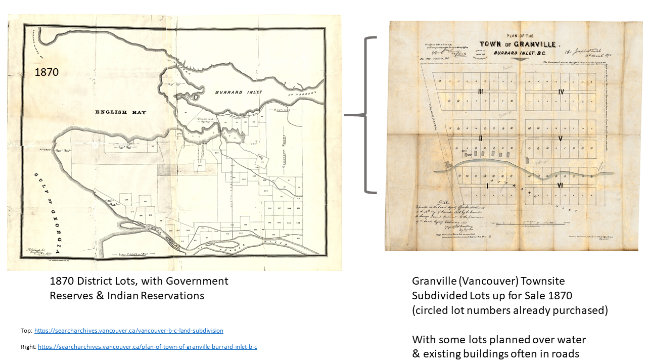
Let’s take a look. The first lots for sale show up for the townsite of Granville in 1870, some 16 years prior to the (renamed) City of Vancouver’s incorporation (archival links: left, right). The lots, carved out of the government reserve, cover old Gastown between Carrall, Hastings, Cambie, and Water St. The latter remains mostly underwater in the map, but the surveyors imagined the future land that now extends beyond Water. Note the disregard for existing buildings outside of lot lines in the map! Several lots (circled) had already been sold or otherwise issued grants of ownership.
By 1886, the railroad had been promised to the City, and in turn, Vancouver had been promised to the railroad. The Canadian Pacific Railroad (CPR) obtained enormous land grants from the province in downtown Vancouver, extending south across False Creek, in exchange for establishing their western terminus in the City. They made similar deals with nearby land owners, obtaining every third lot in the West End (famously pre-empted by the Three Greenhorns) and other districts nearby. The land was quickly cleared of trees and sold off in a speculative frenzy. One of the fires used to clear the brush famously ended up burning the whole city down shortly after its incorporation. But the clearing had to continue apace in order to sell off all the new properties being subdivided and marketed abroad.
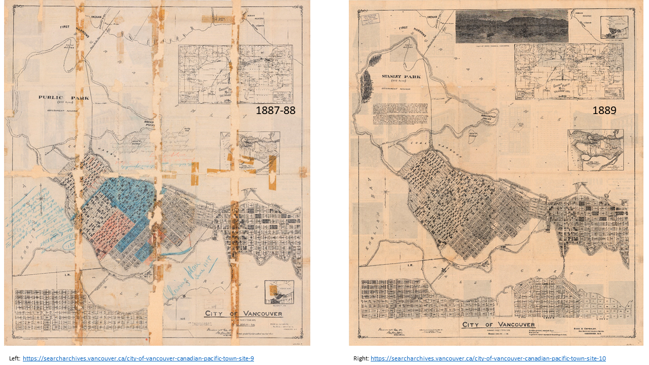
The maps above were printed using the same underlying survey and land subdivision plan, originally authored by CPR land commissioner Lauchlan Hamilton in 1887 (archival links: left, right), whose signature remains on each map (see more from Derek Hayes wonderful Historical Atlas of Vancouver). The more weathered map on the left is annotated and coloured to represent clearing status in 1887-1888, with lots in blue fully cleared, and lots in red just waiting the hauling off of lumber piles. On the right, the same underlying map has been turned into an international sales brochure by 1889, adding lots in Mount Pleasant and highlighting Vancouver’s location alongside travel lines and connections relative to Liverpool, Hong Kong, and Sydney.
The Provincial Government also got in on the sales, slowly releasing their own surveyed and subdivided holdings onto the market via auction. The lots auctioned below would ultimately become the Western third of Kitsilano, centred around McBride Park (archival links: left, right). Sales agents played up the advantageous location of subdivided lots and blocks within lot 540 near the CPR holdings, arguing that the CPR might install a port nearby.
Any Lot of Block not cross-lined on Map herewith, offered for Sale, WILL BE SOLD WITHOUT RESERVE – Adjoining this property the Canadian Pacific Railway Company have located their Docks, it being the nearest Ocean Shipping Point of Vancouver And the place Selected for the Commercial Traffic of the Trans-Pacific Fleet.
Joshua Davies, Auctioneer.
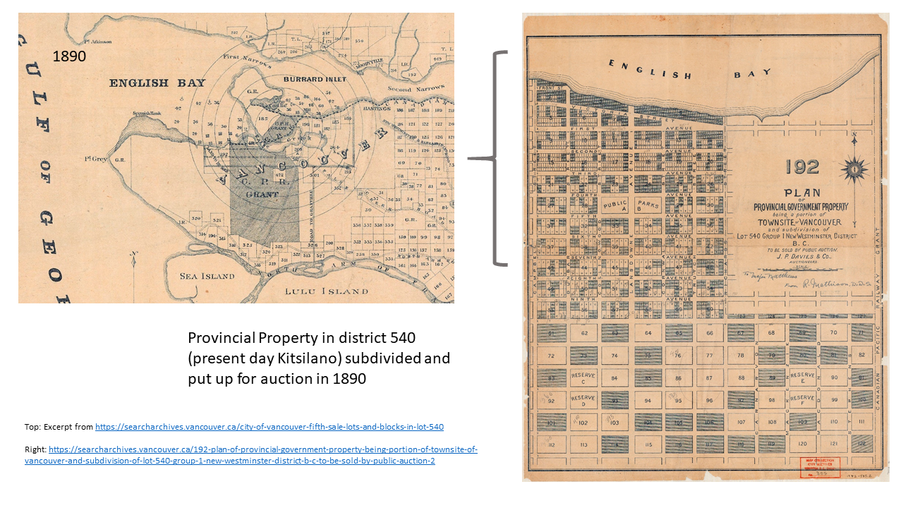
Instead, of course, the CPR subdivided and sold off most of the nearby holdings within their land grant as well. The size of the grant, visible above and comprising roughly a quarter of the present-day City, says a great deal about why Vancouver’s often referred to as a “Company Town.” The company was the CPR, and its business was primarily real estate (see further discussion in Doug Harris’s great piece on “A Railway, A City, and the Public Regulation of Private Property: CPR v. City of Vancouver“).
By 1906, some provincially owned lots remained for sale in District Lot 540. These were auctioned off with other provincially owned lots available in Hastings Townsite to the east and South Vancouver to the south and west (marked in red on left map below). Of note: western portions of South Vancouver would secede to form Point Grey in 1908, before ultimately reuniting in the amalgamated City Vancouver in 1929 (archival links: left, right).
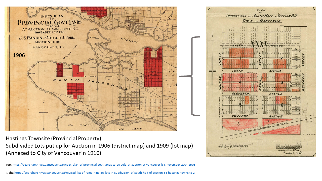
Provincially owned lots in the Hastings Townsite went up for auction again in 1909, as advertised in the map on the right. These were sold on the basis of their proximity to “important and extensive railway yards” associated with the Great Northern Railway and the prominent “99-foot” wide Renfrew Street. Times were given for transit options:
These lots can be reached on the 2:30 Great Northern Railway daily. After 1st April by the First Avenue B.C.E.R. cars, thence along Renfrew Street. Just here will be one of the most important suburban railway stations around the City. TERMS easy; one-fourth cash, BALANCE 6, 12, 18 and 24 months. INTEREST 7%.
Hastings Townsite would vote to amalgamate with the City of Vancouver in 1910. According to an advertisement for the vote in the Vancouver World (dug up by John Mackie):
At last women will have a voice in municipal affairs. On December 10th, if they are registered land owners, women will be able to cast a vote to say whether Hastings Townsite will be annexed by the City of Vancouver or not. In fact, everyone holding property in the said townsite will be given an opportunity. Anglo-Saxons, Orientals, Hindoos, and Africans alike, will be entitled to have a voice in such an important question.
Property ownership entitled owners to a vote in this particular municipal affair, potentially providing a voice to many groups, including most noted above, kept from voting by explicitly sexist and racist legislation at the time. Little wonder that immigrants and others facing discrimination have often devoted their energies toward purchasing property as soon as possible.
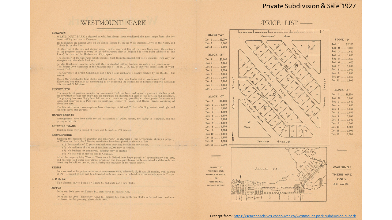
Of course, haters gonna hate. And exclusionary racists gonna discriminate by race. By 1927, the westernmost parts of Point Grey were subdivided and put up for sale. Westmount Park was advertised as The Subdivision Superb, an exclusive set of lots still tucked away North of 4th, just west of Blanca before the UBC Endowment Lands. Lots were sold not on the basis of nearby industry, but rather on beautiful views, nearness of beaches and golf courses and, perhaps most crucially, restrictions:
Realizing the necessity of guarding and conserving the character of the development of such a property as Westmount Park, the following restrictions have been placed on the sale of lots:
- For a period of 20 years, one residence only may be built on any one lot.
- No residence of a vale of less than $4,000 may be erected.
- No business or commercial building may be erected.
- No lots will or may be sold to Orientals.
In the Westmount subdivision we see covenants restricting properties to single-family residential uses directly tied up with classist and racist exclusion. A good reminder that real estate subdivision and sale simply left to the market was terrible at keeping out “undesirables.” The making of a truly exclusive neighbourhood required market restrictions and careful control over development. This particular version of “community not commodity” may have been quite useful to the exclusive agents at Orr-Hamilton Ltd. in selling the lots of Westmount Park (archival link to brochure below).
On a happier note, let’s turn our attention to a bonus map from the Archives. Here we see Kitsilano Indian Reserve No. 6 still set aside on a map of lots in Vancouver in use from 1935 to 1940. Quoting Doug Harris, this was a time period more than twenty years after “…the City and Province induced the Squamish residents to leave the reserve” in 1913, but before “it was formally surrendered” in 1947 (p. 10). We also see the right-of-way forced through by the CPR long before this time. The Squamish reached a multi-million dollar settlement over the shady circumstances of the surrender of the Indian Reserve in 1999. Coming full-circle back to the railroad, in 2002 the Squamish won back the land that had earlier been taken as a right-of-way by the CPR. Of course this win happened only after the CPR, true to form, attempted to sell the land for redevelopment.
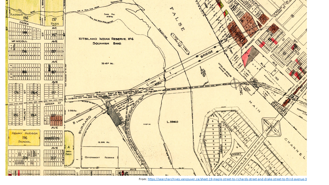
So it is that the peculiarly shaped parcel of land pictured above – extending beneath and around the Burrard Bridge kind of like a big curvy triangle – was returned to the Squamish Nation (archival link). It’s now under development planning as Sen̓áḵw, a massive project aiming to create some 6,000 dwellings, largely much needed purpose-built rental, all tucked in around the Burrard Bridge. See detailed renderings here.
All in all, it’s way too easy to fall into the trap of naturalizing property as currently recognized on land titles in Vancouver. To forget how it was stolen in the midst of successive pandemics, marked off by survey line, written down on paper, then granted or sold off to the highest bidder. We need reminders. Which is one of many reasons to support the City of Vancouver Archives and all their wonderful digital imaging work. They’ve kept the receipts!
