
Most years I take my students on a tour around City Hall, with a focus on showing off various aspects of how City Hall is working (or not) upon the landscape around it. This year, of course, I can’t do that with my classes! So I’m moving the tour on-line, where anybody can come along if they like. Also I’m making the slides linked below available as a PDF document, in case anyone wants to download them and bring them along to walk the route.
We begin the tour at the corner of 10th & Cambie (I usually wait for my class on the stairwell leading up toward City Hall). From there we hook South, East, and North and around City Hall, continuing North on Yukon till we turn West on 7th, slinking our way on down toward False Creek. Here’s what the route looks like mapped out on Google Maps, which is where anyone can follow along virtually.

I’d recommend toggling back and forth between street view and satellite view in Google Maps for best effect. The reason I carve this particular route has do with how it maps over top of various key zoning transitions within the City, directly governed by City Hall. So let’s substitute this map for another one, labeling the underlying zoning districts and laying out stops along the way. The base map I’m using comes from my joint project with Jens von Bergmann looking at zoning all across Metro Vancouver.
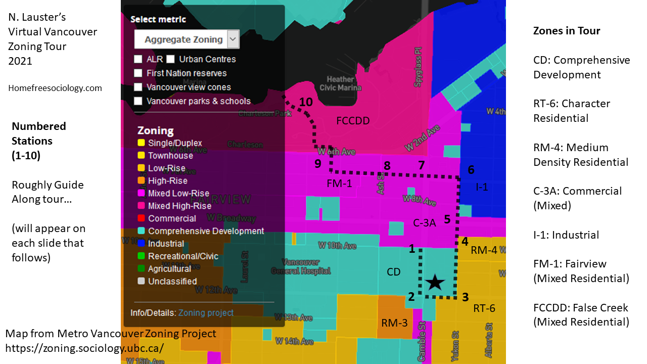
From here on out, I’ll organize the tour by number of the stop along the way.
Stop 1. 10th & Cambie
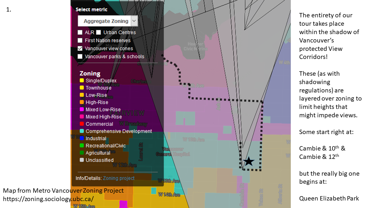
From the steps leading up to City Hall on the SE corner of 10th & Cambie, it’s worth looking to the North, toward downtown and the mountains beyond. How much is it worth? That’s a good question. For the City of Vancouver, its apparently worth quite a lot. This view is specifically protected by City policy, as first adopted in 1989. In fact, the entirety of our tour lies within protected view cones, with the largest one extending from Queen Elizabeth Park. View cones have distinct effects upon what can be built in Vancouver in terms of height and massing that might be considered as disrupting views, and these are layered over top of more direct zoning regulations. Shadowing policies can have similar effects, adding up to a complex set of regulations governing construction beyond simple zoning. But, as we’ll see, zoning is often not simple either.
From stop one, we’ll turn our gaze southward, away from downtown, the mountains, and the near Commercial buildings to our North. Then we’ll march along City Hall toward the intersection of 12th & Cambie. As we do so, we find ourselves passing through lands that have been “spot zoned,” or set aside on a lot by lot basis from the standardized zoning categories governing Vancouver’s development.
Stop 2. 12th & Cambie
Once we arrive at 12th & Cambie we find ourselves completely surrounded by spot-zoned Comprehensive Development (CD) lots. Indeed, the newest of these, at the SE corner of the intersection is actually called “The Spot” though it gets its name from the former White Spot restaurant that used to occupy the site rather than from its spot zoning. Initially CD zoning was employed to enable uses for lots deemed desirable, but not in fitting with standardized zoning categories (the Oak Ridge Mall was Vancouver’s first CD). Over time CD zones have proliferated dramatically, with each lot calling for its own bylaw passed by council, and Vancouver has become famous – or infamous – for its spot zoning practices. CD zones open up direct negotiation between developers and the City, with Community Amenity Contributions often being offered (not without controversy) as a developer gift to the City while CD zoning entails greater density or different uses for developers than allowed by standardized zoning categories. Working through a CD rezoning can ultimately be profitable for market-oriented developers, but the process can also be lengthy, onerous, uncertain, and expensive.
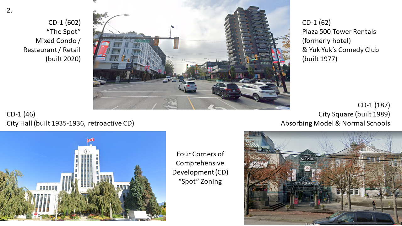
The lots at 12th & Cambie demonstrate both the proliferation of CD zones and their changing structure over time. City Hall was shifted to a CD-1 (46) zone in 1968, three decades after its construction, likely just to reflect its distinct use. Recent amendments added on-site “Public Bike Share” as an allowed use, but otherwise the bylaw governing City Hall remains sparse. If anything, the CD-1 (62) bylaw governing The Plaza 500 (passed in 1970) is even more sparse, simply enabling “Retail stores, Professional Offices, Restaurant, Lounge, Apartment and Hotel-model” uses on-site, including ancillary facilities like a “Beverage Room.” The City Square rezoning into CD-1 (187) from 1986, enabled the incorporation of the old heritage Model School and Normal School buildings into a small shopping mall, and contains somewhat more complex language and code, including a wider range of specified uses, and a maximum Floor Space Ratio and Height. “The Spot” was rezoned as CD-1 (602) in 2015, with the number indicative of the dramatic growth of CD zones over thirty years’ time. Code complexity has grown as well, incorporating Horizontal Angle of Daylight and acoustic concerns. “The Spot” provides an exemplary of what people often imagine CD zones are doing in combining Commercial (at grade) and Residential (above) uses, hence enabling a mix falling outside of codes separating these uses and adding much needed housing. In reality, as revealed by our Metro Vancouver zoning map, CDs are employed for all sorts of uses, with most of our largest by land area being institutional (e.g. the PNE Fairgrounds, Mountainview Cemetery, Major Hospitals).
Stop 3. 12th & Yukon
As we move off Cambie, walking Eastward on 12th, the landscape changes remarkably. By the time we reach Yukon, the SE corner of City Hall is surrounded by big old houses set behind leafy trees. Each corner of the intersection (including City Hall) is now recorded in Vancouver’s Heritage Registry. And we now find City Hall surrounded by the RT-6 zone.
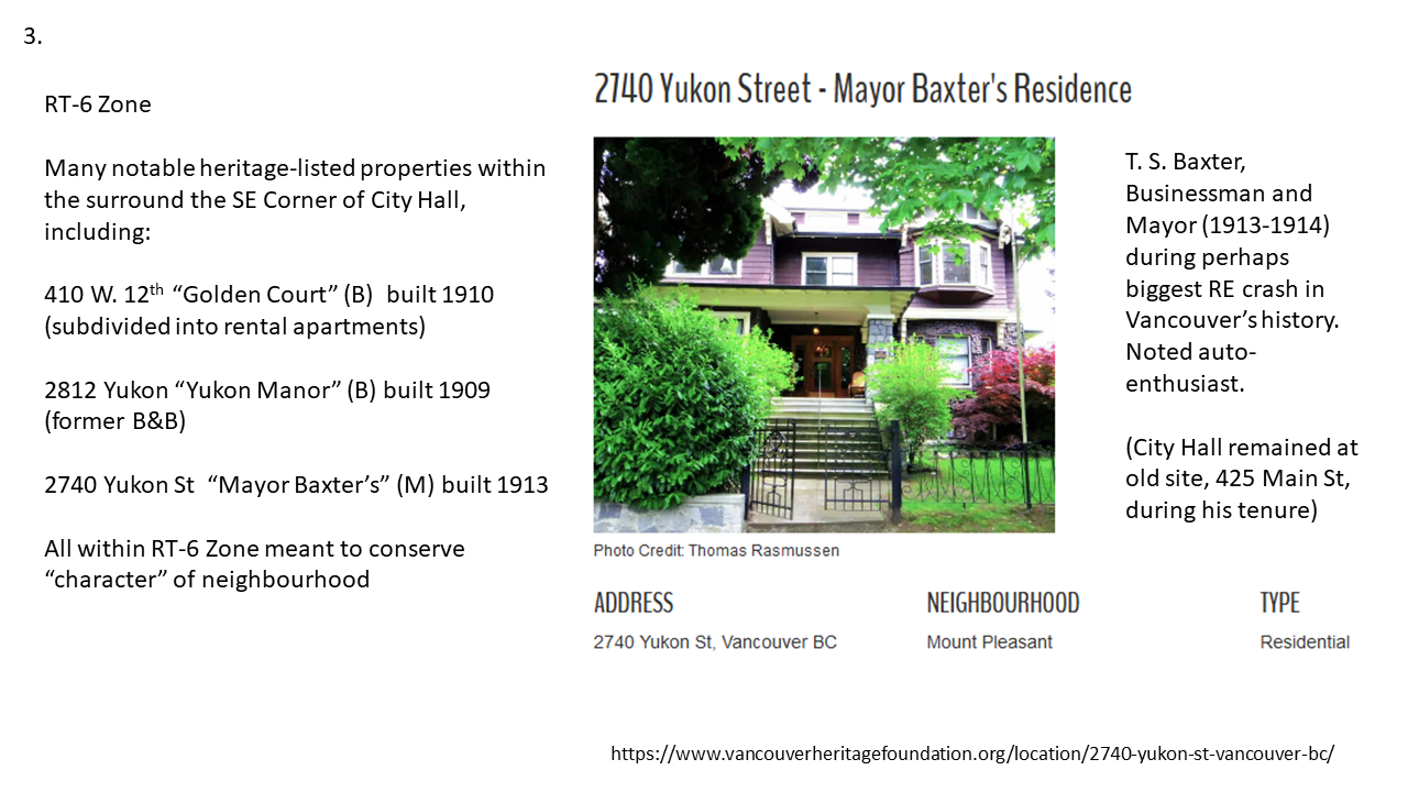
We can see a high density of heritage registered properties extends further than the corners, across the RT-6 zoning nearby, here made visible through the Legacy (heritage) version of Vancouver’s VanMap. But we’ll encounter a few more later along our walk.
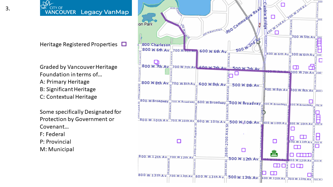
The overlap between RT-6 Zoning and Heritage Registered properties is no accident. Indeed, the RT-6 zone is practically a living museum zone, intended to promote the “restoration of existing residential buildings” and maintain “the historical architectural style and building form consistent with the area.”
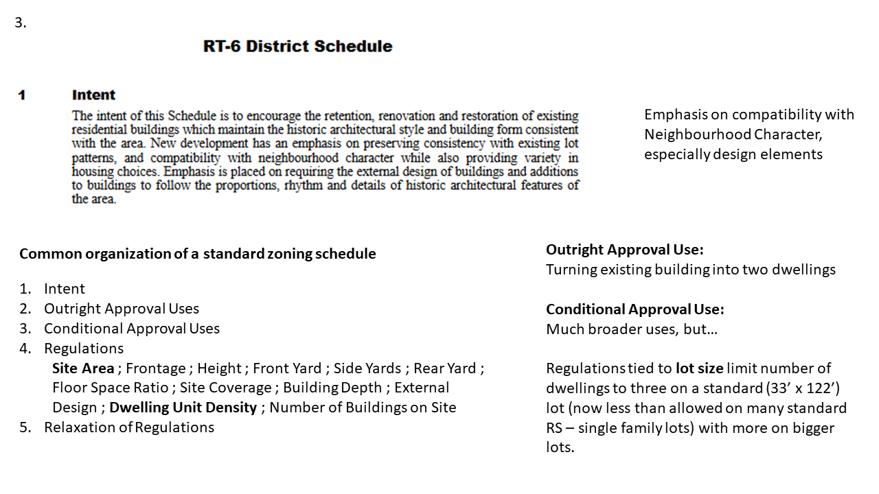
The RT-6 schedule is worth perusing in full to enjoy the minute detail paid to limiting and guiding local redevelopment. This RT zone also has a lengthy set of regulations, including some rules, like Dwelling Unit Density, not commonly seen elsewhere in the City of Vancouver. Despite the broader range of uses theoretically allowed under conditional approval, these arcane regulations actually limit what can be built on a standard size lot in Vancouver to fewer dwellings than can now be built under the low density RS (“Residential Single Family”) zones that occupy the bulk of the further flung parts of the City of Vancouver. Though we’re not passing through it here, I’ve got a whole book on Vancouver’s RS zoning for anyone interested!
Stop 4. 10th & Yukon
Heading further North along Yukon, we come to the intersection with 10th, allowing us a peek at a tiny pocket of RM-4 (“Residential Multifamily”) zoning. Multi-family zoning has often been allowed and justified as a kind of transition or shield between commercially (C) zoned strips and lower density (RS and RT) zoning. Here we can see that while the zoning allows apartment buildings, it’s still only a conditional use, requiring approval from Vancouver’s Chief Planner.
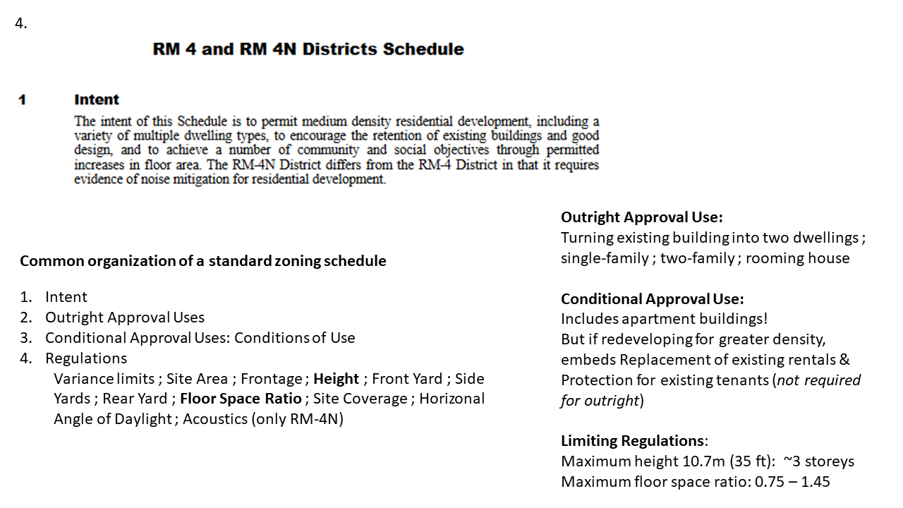
RM-4 zoning allows for only relatively low-rise apartment buildings, maxing out at about three storeys (or perhaps four, with a sunken first floor). As we gaze Eastward along 10th,we see that the townhouses to the right fit just fine, though they likely obtained some extra density (Floor Space Ratio) in exchange for fixing up the heritage Grauer House behind them. Yet on the left we’re immediately confronted with a seven storey building: The Lutheran Manor. How did it get there?
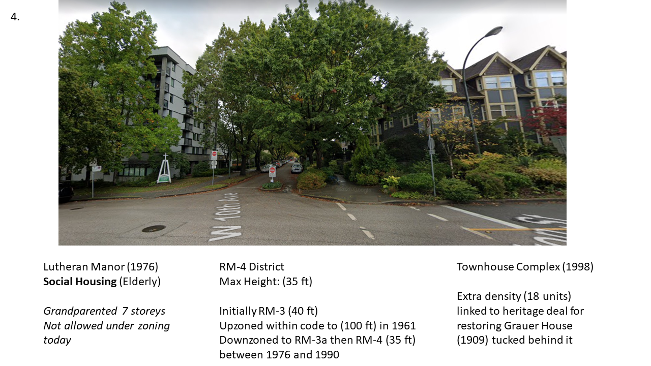
As it turns out, Lutheran Manor was built during a relatively narrow window in time between 1961 and the mid-1970s, when the land it sits on had been zoned RM-3, and the maximum heights on RM-3 were lifted to 100 ft. Lutheran Manor narrowly escaped the great downzoning that subsequently swept across Vancouver’s RM sites under TEAM in the 1970s, lowering maximum heights to 35 ft, and ultimately rezoning many former RM-3 parcels to the more restrictive RM-4. So effectively, Lutheran Manor was built under different rules, and could not be rebuilt under its current zoning today. What’s great about Lutheran Manor is that it’s also Non-Market Social Housing, which relatively scarce across the City of Vancouver. Lutheran Manor’s non-conforming status, meaning it doesn’t meet its zoning, helps explain how our current zoning rules work to really limit the construction of new Social Housing.
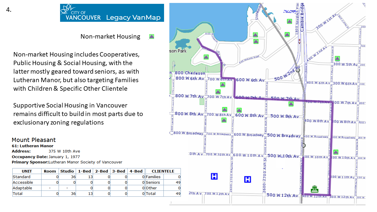
As we can see via its listing linked to VanMap, Lutheran Manor exclusively serves Seniors, offering a mix of Studios and 1-Bedroom apartments to that end. Much of our existing Social Housing stock is similarly modest in size and serving specialized groups, like seniors and families with children. As a final note before moving on, the City of Vancouver has recently discussed a policy shift re-enabling buildings like the Lutheran Manor in RM-4 and related districts. The basic idea is that non-profit housing applicants could be enabled to build up to six storeys in these zones without going through an expensive, lengthy, and uncertain re-zoning (CD) process.
Here I’ll just return to our guide map to point out that we’re about to head North to Broadway, crossing definitively into the C-3A Commercial zone, and setting us off to our next stop!
Stop 5. Broadway & Yukon
And now we’re on Broadway! Vancouver’s primary Commercial Strip outside Downtown. In normal times, this was also purportedly the most frequently traveled bus corridor in Canada or the USA (who doesn’t love the 99 B-Line!) And the Broadway Subway is coming soon, initiating a new City Planning exercise for the area. Entering Broadway strip, we’re also entering the C-3A Commercial District. Let’s take a quick look at what kinds of uses are allowed.
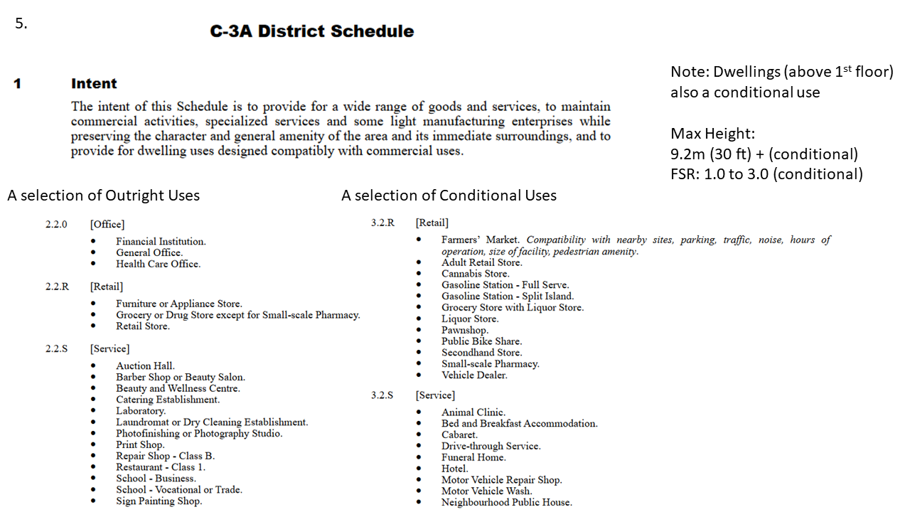
The above is only a sample of outright and conditional uses. What a shift from RT and RM districts! At the same time, it’s striking that each potential use has to be directly specified to be allowed. This is how zoning works; by directly legislating what’s allowed and thereby forbidding everything else. It’s dramatically more conservative from the regulatory approach that dominated prior to zoning, where certain objectionable uses (e.g. tanneries) were specifically restricted, but all other uses were allowed by default. Here any new use has to find some old category to fit under or risk being defined out of code. Dwellings are conditional uses within C-3A zoning, but often not allowed on the first floor. Let’s take a look at the streetscape to the West.
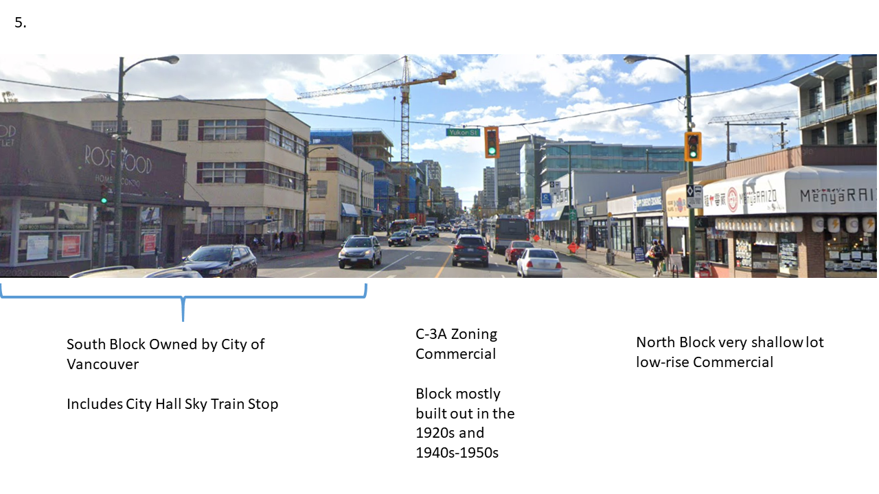
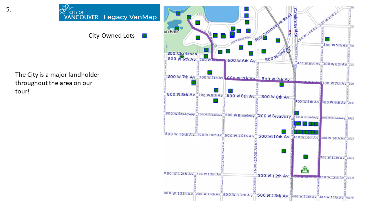
The block running between Yukon and Cambie is largely older, low-rise buildings, most dating from either the 1920s or the post-WWII era. On the right (N) side of the block, the view from above reveals that the stubby little buildings are on very shallow square lots. These shallow lots run all along the North side of Broadway between Cambie and Quebec streets, and seem relatively resilient to redevelopment, likely reflecting the difficulty of building anything else upon them given the difficulty of addressing issues like parking by-law (6059) requirements within the small lot footprint. Parking requirements are typically layered beneath zoning requirements, like an underground garage in code form. As for the peculiarly shallow lots, these were produced by historical accident of the misalignment between the streets and lots on the West and East sides of Cambie, corrected at Broadway. On the left (S) side of the block, all of the normal-sized lots between Yukon and Cambie are actually owned by the City! They were likely purchased in planning for some combination of future City Hall and SkyTrain (or Subway) expansion. We can see all the City-owned lots in the area by mapping them out on VanMap.
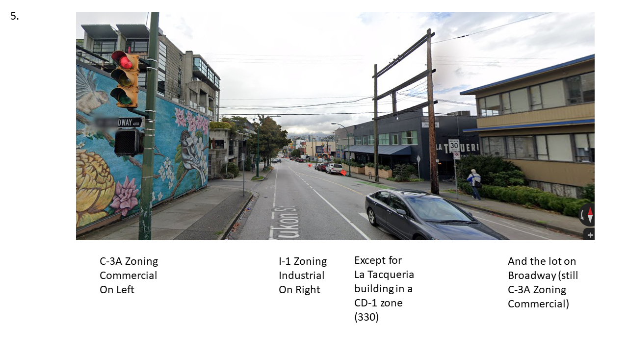
As we cross Broadway, we’ll continue heading North on Yukon. As we pass the lovely mural on the side of the stubby little building on our left, we very quickly we encounter a split in our zoning, with the left ![]() side of the block still C-3A Commercial, but the right (E) side of the block turning over to I-1 Industrial. But before we get there, we’ve also got another little CD-1 (330) zoned parcel tucked in on the right, with one foot in continuing the Commercial strip with La Taqueria Pinche Taco Shop facing Yukon, and the other foot in Industrial, with Sherwin William Paints and Reliable Parts appliance part sales wrapped around the corner facing 8th.
side of the block still C-3A Commercial, but the right (E) side of the block turning over to I-1 Industrial. But before we get there, we’ve also got another little CD-1 (330) zoned parcel tucked in on the right, with one foot in continuing the Commercial strip with La Taqueria Pinche Taco Shop facing Yukon, and the other foot in Industrial, with Sherwin William Paints and Reliable Parts appliance part sales wrapped around the corner facing 8th.
Stop 6. 7th & Yukon
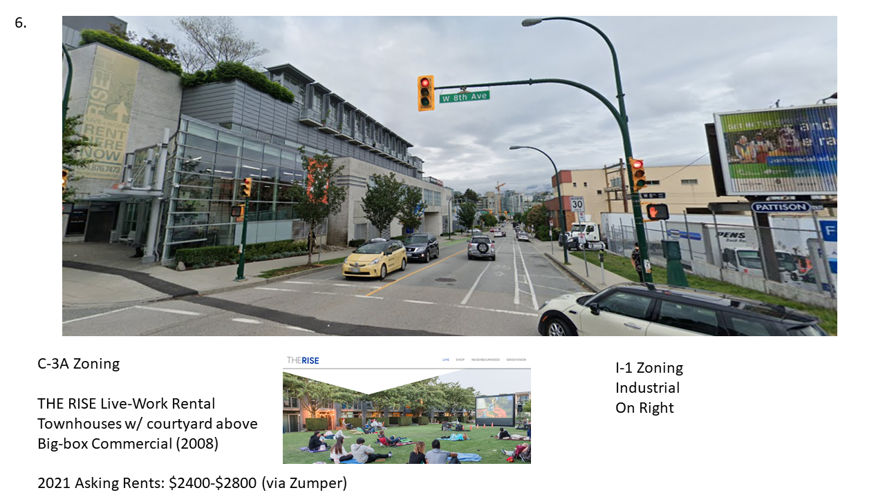
As we pass 8th and approach 7th & Yukon, our stop six, we get a better view of the Commercial ![]() – Industrial (E) split. On the Commercial (C-3A) side we see the back side of the boxy building containing Home Depot, SaveOn Foods and a variety of other stores.Up above the big box of assorted retail, somewhat strikingly, rest the rental live-work townhouses of The Rise, surrounding a central courtyard viewable from overhead (or from The Rise’s marketing website).
– Industrial (E) split. On the Commercial (C-3A) side we see the back side of the boxy building containing Home Depot, SaveOn Foods and a variety of other stores.Up above the big box of assorted retail, somewhat strikingly, rest the rental live-work townhouses of The Rise, surrounding a central courtyard viewable from overhead (or from The Rise’s marketing website).
On the Industrial (I-1) side of Yukon between 8th and 7th we see the fenced off parking lot supporting Freeman Audio Visual, a company providing technical support for on-site events (apparently about to move locations), and a pink-ish building further down houses Van Bind manufacturing, which assembles a variety of promotional items. Let’s take a closer look at what’s allowed in the I-1 Industrial zoning.
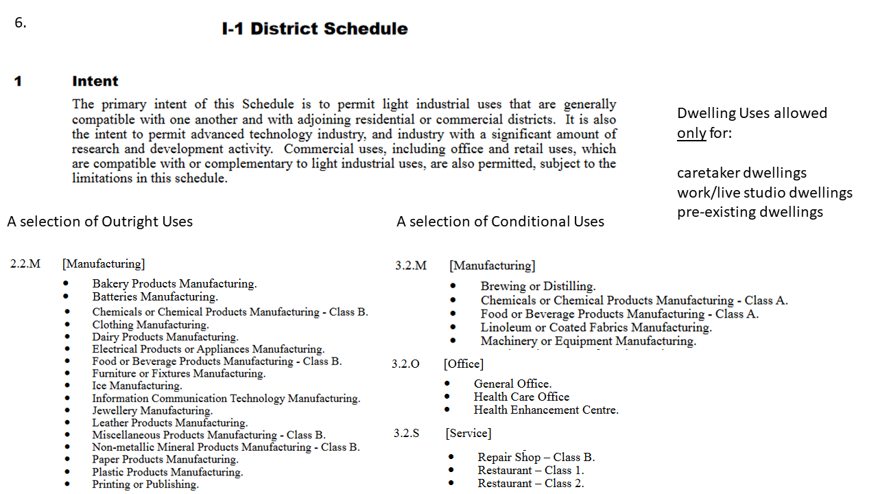
There are a lot of outright and conditional uses specified for I-1 Industrial zoning, just like we saw with C-3A Commercial zoning. The same general principle applies, we specifically name all the uses we might think acceptable, and disallow anything not otherwise named. This conservative strategy, labeling established and past manufacturing uses, may end up at odds with the high tech intent “to permit advanced technology industry, and industry with a significant amount of research and development activity.”
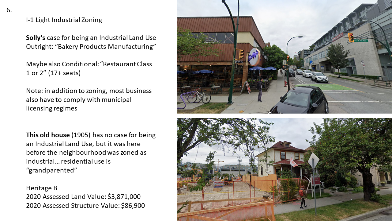
Arriving at 7th & Yukon, we see a new conundrum on the Industrial (E) side of Yukon. What’s a bagel shop and an old house doing here? As it turns out, they both fit!
We can use the existence of the old house to jump back in time to 1912, when the old house was relatively new, but use-based zoning hadn’t been introduced to Vancouver as yet. I’m assembling this map of what our tour looked like in 1912 from two plates (26 and 28) of the Goad’s Atlas of the City of Vancouver, accessible through The City of Vancouver Archives.
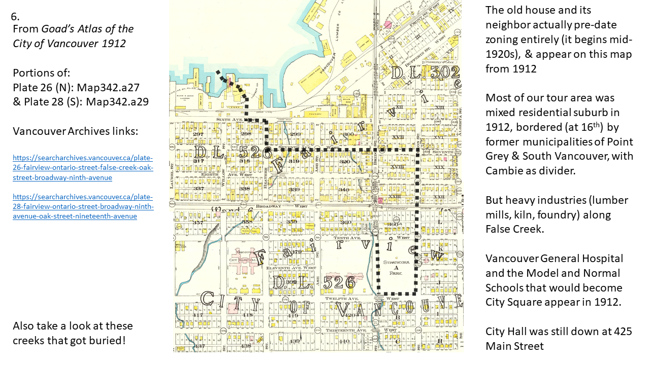
On the map from 1912 Cambie Street wasn’t even Cambie Street as yet, but rather simply called Bridge Street. The misalignment between the East and West sides of Bridge Street is even more apparent, producing those shallow stubby lots we saw along Broadway. Before zoning, most of the area we’ve passed through so far looked pretty residential, though there are a few other buildings mixed in, like a bank on Broadway and the Model and Normal Schools that would merge into City Square.
Strikingly, even after zoning arrived to Vancouver in the form of preliminary bylaws passed through the late 1920s, the area containing and surrounding our old house wasn’t zoned Industrial. It was first zoned as a residential neighbourhood! But through a process of zoning change over time, Industrial zoning was expanded from False Creek up to Broadway, then retracted into the formerly residential parts of Mount Pleasant we’re now passing through on our tour.
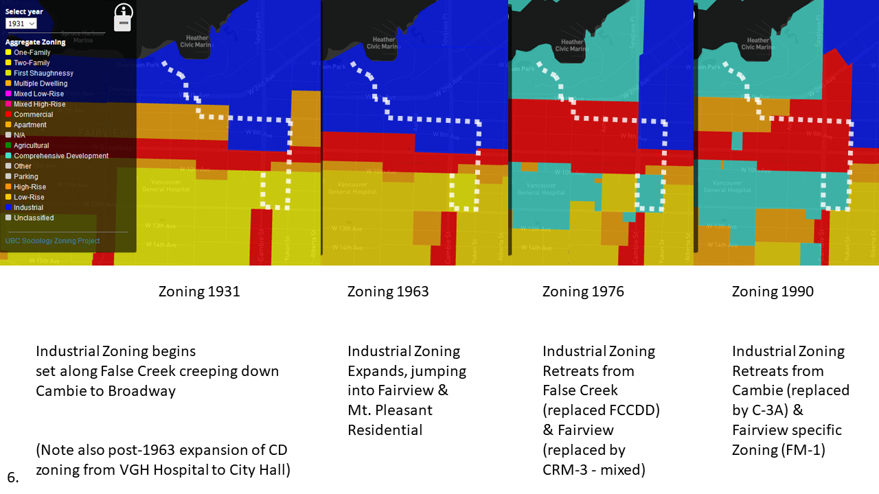
Put slightly differently, mapping the history of this area’s Industrial zoning looks a bit like mapping the passage of an enormous slug heaving itself up from the waterfront and across Cambie Street between 1930 and 1990. What happened to the post-industrial land it left in its wake? Below we can see the timing of when various buildings in the area were constructed, relying upon Building Age as recorded in BC Assessment data, and helpfully mapped by Jens over at MountainMath. The trail of green left behind by former Industrial zoning definitely matches our slug imagery, and indicates that most of the buildings we’ll be passing by from here on out will have been built in the wake of Industrial zoning’s slow passage. Let’s head Westward into some post-industrial slug-slime!

Stop 7. 7th & Cambie
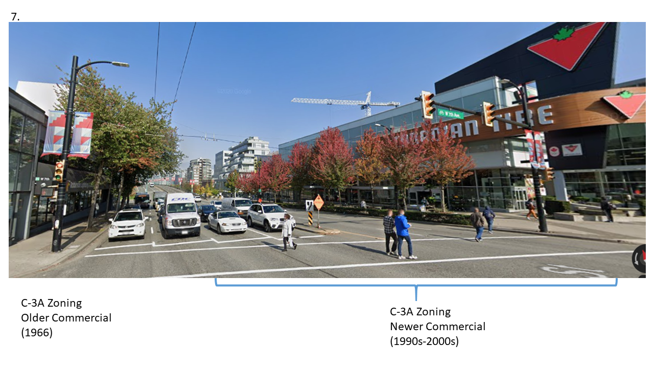
As we return to Cambie Street, we re-enter the C-3A zone, but recall that this zoning was only recently put in place on the East side of Cambie. On the West side of Cambie it’s been in place longer. Sure enough it tracks with the view! The Canadian Tire store appears in a building only constructed in 2004, and similarly new-ish buildings are visible further to the North. To the left (W), the building housing the Robinson Lighting & Bath Centre has had some touch-ups, but it’s been there since 1966, likely constructed just as Commercial zoning replaced Industrial.
As we cross Cambie, we also get a hint of the misalignment along 7th Avenue from one side to the other (it’s more obvious up on 8th). Sticking along 7th Westward, the post-industrial C-3A Commercial zoning continues off the Cambie strip. On the right (N), we can see a continuation of shops and related commercial uses on lower floors,with condominium apartments above. On the left (S) we finally come across another instance of Non-Market Housing!
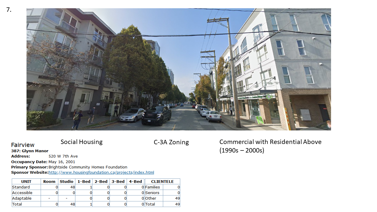
The Glynn Manor social housing, run by Brightside, is (somewhat unusually) targeted at youth. It operates with support from the provincial BC Housing agency on land owned by the City of Vancouver and leased to the housing provider, demonstrating the ways that multiple governments often operate together to support Social Housing. More of this please!
Stop 8. 7th & Ash
We continue on down 7th toward Ash, with shop and office fronts following alongside the right (N) side of the block for at least half way down. But it’s notable that while it remains tucked within the C-3A guidelines, we also get some condo buildings (fitting within conditional uses requiring approval of the Director of Planning), and the on the left (S) side of the street we generally don’t retain commercial frontage at street level at all. Instead we get a condo building and a large office complex (housing the BC Cancer Foundation), up until we get to the little house at the end of the block containing the Caffe Cittadella.
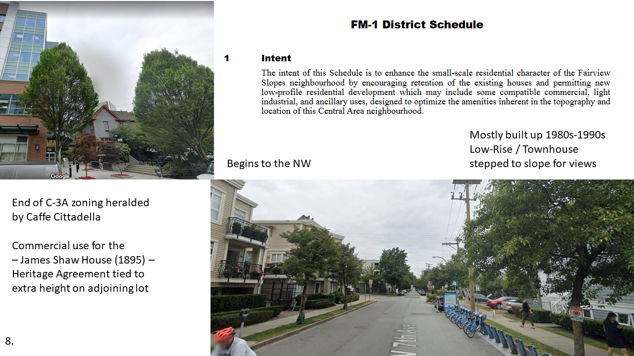
On the North (R) side of the block, the zoning shifts at Ash to the neighbourhood-specific FM-1 Fairview zone, replacing a rapid turnover of previous RM, I, and CRM (early mixed use Commercial) zones. Most of the area was redeveloped in conjunction with the FM-1 zoning, ushering the close townhouse oriented developments characterizing the area today.
Stop 9. 6th & Moberly
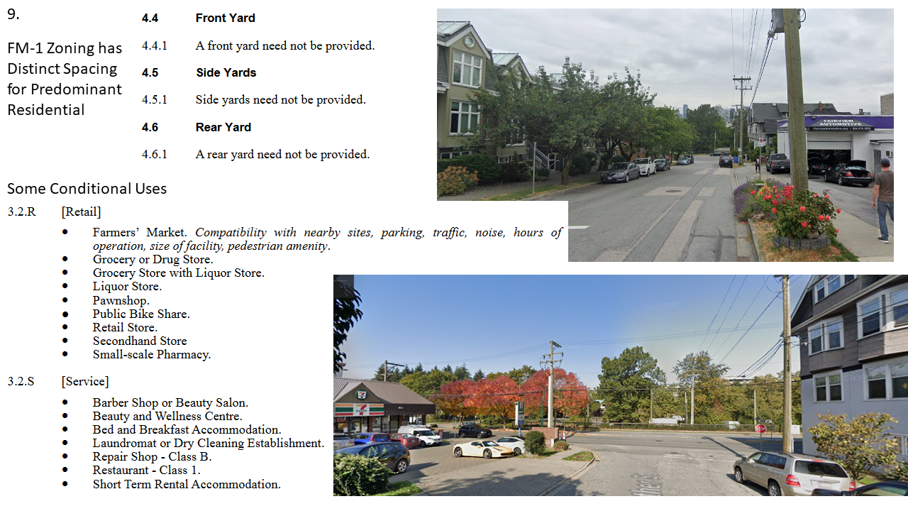
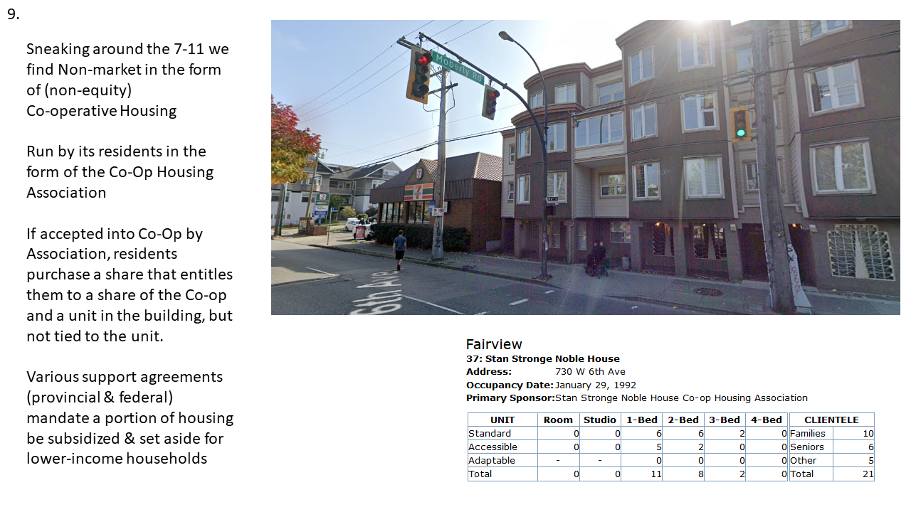
We continue through the FM-1 zone as we make our way down toward False Creek, with some of the remaining mixed uses encouraged by the zone showing up here and there, as with the auto-repair shop (more characteristic of Industrial zoning) and the 7-11 in the mini strip-mall on 6th (more characteristic of Commercial zoning). The distinct “close together” look of the zone is emphasized by the lack of yard requirements or setbacks, unusual for a largely residential district.
As we turn the corner onto 6th, we arrive at yet another notable instance of non-market housing! This time it’s a co-operative: The Stan Stronge Noble House. I describe the basic features of co-operatives below, but head on over to the Co-operative Housing Federation of BC for more.
As we cross 6th Avenue, a street turned over to busy arterial use, we can see how it works as a barrier to False Creek and the neighbourhood where we’re heading. But it’s not the only barrier, we also cross some railway tracks linked back to an old CPR right-of-way, a short-term Olympic streetcar pilot, and a more contentious future (you can let Uytae Lee break it down).
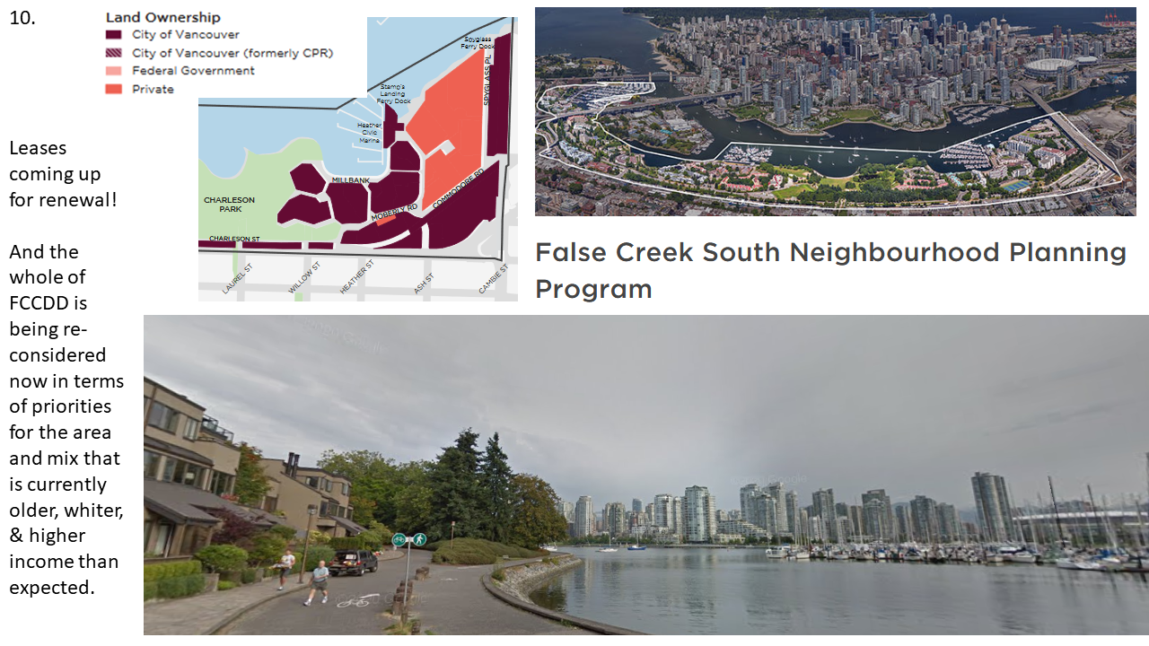
Stop 10. Sawcut & Greenchain
On the other side of the tracks we find ourselves in a new zone, designed to operate kind of like a gigantic CD zone. Indeed, it’s literally called the False Creek Comprehensive Development District (FCCDD). The zone was created in conjunction with a massive effort in the 1970s to transform the post-industrial southern shores of False Creek into a new residential district, owned primarily by the City of Vancouver, and enrolling the federal assistance of the Canada Mortgage and Housing Corporation (CMHC) in the effort. Somewhat incongruously, the CMHC still owns Granville Island! (And has also generously funded our efforts at keeping tracking of Metro Vancouver zoning).
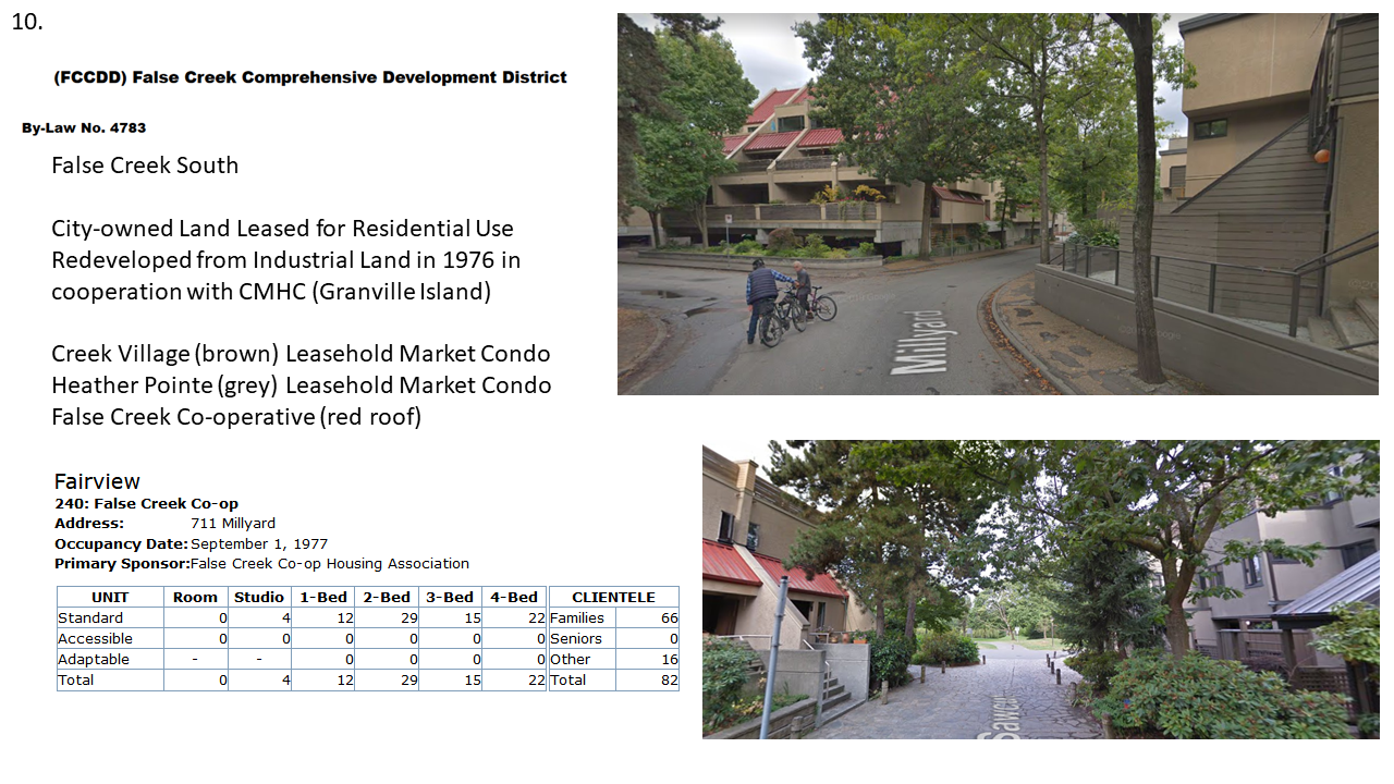
Walking through the False Creek Development District is like stepping back in time, in this case very precisely to 1976, when all of the surrounding buildings we see on our walk were constructed. The particular vision was very much in keeping with a 70’s self-expression vibe, but also involved specific ideas about creating an accessible residential mix. The City retained ownership of the vast majority of the land across the FCCDD, leasing some sites to member run non-market housing provides, like the False Creek Co-op, while leasing other sites to private strata (condominium) buildings, in the hopes that lease-holds might lower barriers to ownership. Examining the Community Profile has raised new questions about whether the results reflect the desired aim in terms of social mix. As the leases are coming up for renewal, the City is currently working toward planning for how the neighbourhood should change in the future.
Finally, as our Virtual Vancouver Zoning tour comes to an end, we can look across False Creek toward the towering skyline of the Downtown peninsula. I’ve got another on-line tour of sorts set over there, taking interested parties (including my classes) back and forth in time and following the paths of Vancouver’s famous 1907 trolley ride video! But I hope this little jaunt around City Hall has convinced you that lots of interesting stuff is going on outside of Vancouver’s downtown core. More to the point I hope I’ve convinced you that all the stuff going on in City Hall, in terms of its zoning and related regulatory powers, is actually really, really interesting, with consequences you can see on the street!
Note: As always, please send me any corrections and fixes! Currently dated to March of 2021, I will likely return to update this post in the future in support of the tour and changing conditions on the ground.

Wow this is a great way to teach planning and zoning. Thanks for the detailed explanation.
I may (will definitely) copy this approach!
Have a great weekend. Imelda
On Thu, Mar 4, 2021 at 4:52 PM Home: Free Sociology! wrote:
> Nathan Lauster posted: ” Most years I take my students on a tour around > City Hall, with a focus on showing off various aspects of how City Hall is > working (or not) upon the landscape around it. This year, of course, I > can’t do that with my classes! So I’m moving the tour on-line” >
LikeLiked by 1 person
Thanks for the resource an dthe great tour 🙂
LikeLiked by 1 person