
A couple of weeks ago I took my urban sociology class on a tour of downtown Vancouver. We followed the route of the captivating film of downtown shot from the front of a trolley in 1907. The trolleys! The street life! The bicycles! The horse manure! Well worth a watch.*
Our tour began at UBC Robson, but then we joined up with the trolley film just outside of the former Hotel Vancouver, on Granville and Georgia. From there we proceeded down Granville toward the old Canadian Pacific Railway (CPR) Station, before turning right on Hastings. The trolley stayed on Hastings till Carrall, and so did we. Then, following the film, we jumped down to Carrall at Cordova, and come back Cordova until returning to the intersection of Cambie & Hastings. At that point we parted ways with the trolley film (which speeds off to parts of the West End), and made our way over to Chinatown.
I tracked down old fire insurance maps to accompany our tour, providing an overhead view of the route and its surroundings from roughly 1889, 1901, and 1920. These took a little work to assemble from the City of Vancouver Archives (1899 and 1910-1920) and the Collections Canada (1897-1901), but thankfully pretty much all of the pieces were there (see below)! Here’s the basic overview of the route in animated gif form, tracking through each year, with an overlay from 2020 tacked on at the end. A little crude in assembly, but wild fun!
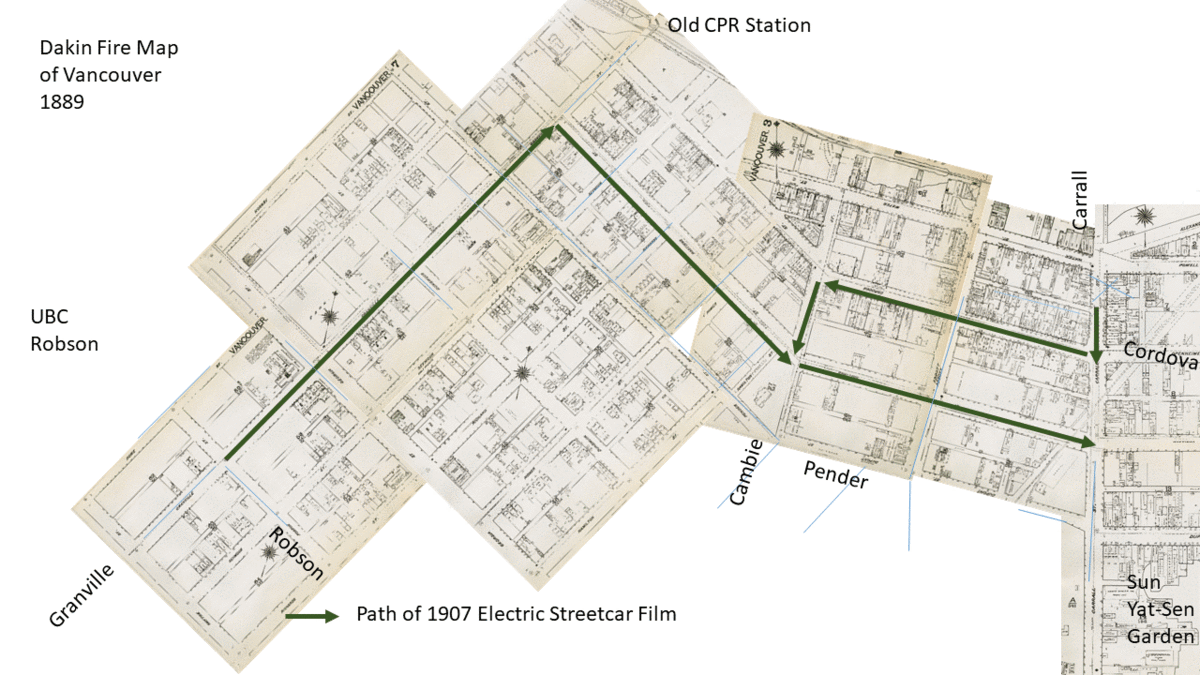
The maps document how Vancouver grew from 1889 (three years after the City’s incorporation as well as the Great Fire that burned it all down!) through its early years up to 1920 (just after WWI and the great flu outbreak of 1918). A few big patterns are immediately evident. First, old Vancouver was still pretty sparse in 1889, and mostly centred around the old Gastown area (Carrall & Cordova above). By 1901, there were still large stretches of the trolley route relatively barren of buildings, but a booming decade ahead successfully built out the city, ending with a spectacular bust in 1913 (followed by a world war and the terrible flu year of 1918). Second, the CPR succeeded in pulling the young City of Vancouver westward toward the Hotel Vancouver (which it owned) and its sizable property holdings down Granville Street. Vancouver (a.k.a. “Terminal City”) was both the end of the line and the start of numerous speculative real estate fortunes. Third, as the city grew, its old buildings – especially its early shacks and dwellings – quickly made way for more substantial buildings. Before the advent of zoning, the urban core of the city was allowed to grow both upward and outward. Many of the buildings on the maps by 1920 remain in existence (and protected under heritage agreements) today.
Let’s zoom in a bit and follow the trolley along for a little e-tour…
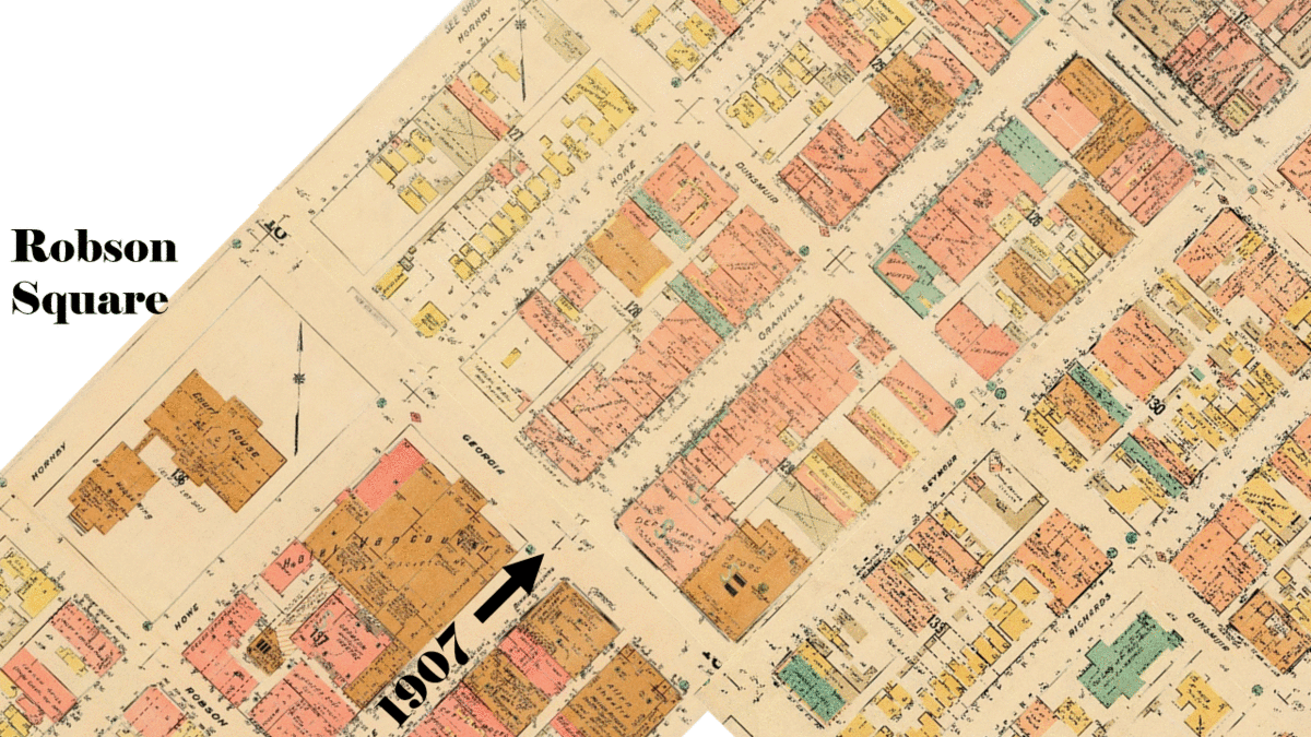
I’ve added flags for some of the fun things to see in the 1907 trolley movie, as well as the 1910-1920 Goad’s map I’ve used as an underlay. In the description below, I’m also timestamping (x.xx) some of the sites in the film. We start outside the Second Hotel Vancouver (5.15), at the end of a block I’ve examined in-depth before! From there we pass the Hudson’s Bay store (still there!) Then I highlight some of the off-Granville features of the map, including the old houses along Howe and Richards streets. Of course many of these houses were actually side-by-side semi-detached houses. Not far away were townhouses, cabins, and an array of other kinds of housing. Rooming houses were also popular, and hotels were not neatly distinguished from apartment buildings. So it is that the Hotel Badminton (on the 1901 map) becomes the Badminton Apartments by 1920. Once surrounded by other churches, Our Lady of the Holy Rosary Catholic Cathedral remains downtown. My first foray into old fire insurance maps took place across Dunsmuir, when I examined historical change in the blocks near Cathedral Square. Next we pass the old turretted Bank of Montreal building (5.32) and then we scoot the map northeastward.
[see Vancouver Archives Goad’s Map: Plate 18 ; Plate 16]
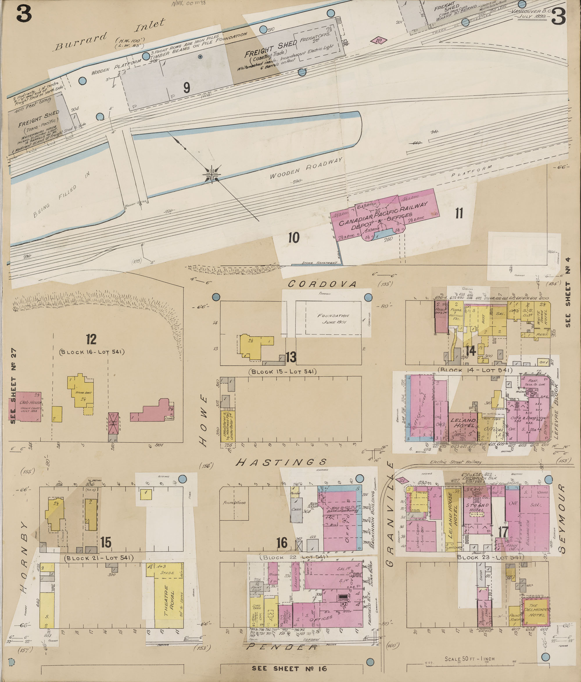
Now the Gothic old Second CPR Station is visible at the end of Granville St. It doesn’t show up on the map from 1920 because it was torn down around 1915, when the new Waterfront Station was built nearby. Before we get there, we pass the Sun Ban Japanese store (5.48), the sign visible in 1907 (colourized-photo from image #4 here). Not far away was the Japanese consulate, showing up on the 1901 map, and indicative of the strong trans-Pacific ties that characterized Vancouver’s early days. The beautiful old post office building from 1905 sits at the corner of Granville and Hastings, and that’s where we turn Eastward on Hastings, swinging around the Birks Clock (5.58), back in action today!
[see Vancouver Archives Goad’s Map: Plate 16 ; Plate 3]
Heading down Hastings, we move into a heavy banking district, passing the Molson’s Bank (6.24) on the left, and what would soon become the Union Bank on the right, now SFU’s Morris Wosk Centre. The streetscape is currently dominated by the Harbor Centre, looming over us as we scoot the map a little further Southeast. Just to highlight how much fun it is to zoom in on the high-resolution archival versions of these old maps, I highlight a few of the buildings off Pender & Homer. Look at those mixed uses! The Ellesmere Boarding House (in yellow) sits above mixed shops and offices. Across the street sits the Hartney Chambers (1909), containing printing, offices, and apartments on the 3rd floor. Behind are more offices, but also a billiards hall and an auctioneer space, with a dance hall above and a bowling alley below. Heading further down the street, Vancouver’s landmark Dominion Building wasn’t yet built in 1907. Instead we pass a drug store connected to an arcade (6.54) before Hastings swings left at Cambie. There’s also no Victory Square across the street, because there had as of yet been no victory in WWI. instead the space was known as Government Square, and contained the old court house (before it moved over to Robson Square, near where we began).
[see Vancouver Archives Goad’s Map: Plate 3 ; Plate 4 ; Plate 5]
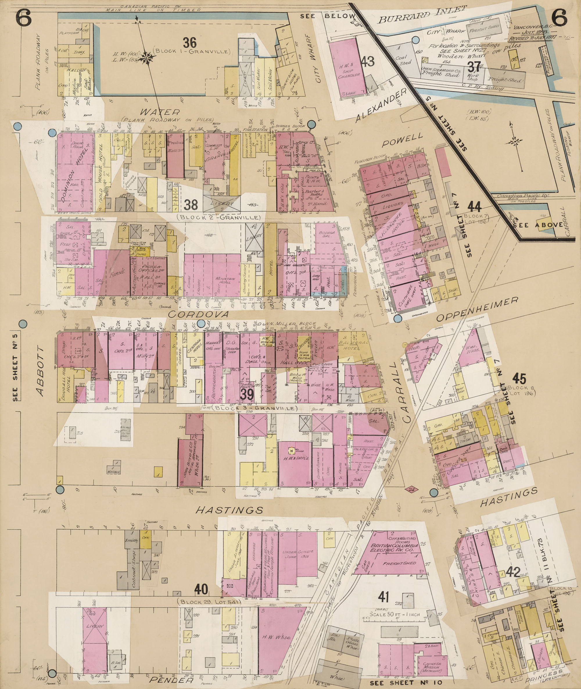
As we follow the turn in Hastings Street, we get a fabulous view of some of the signs and storefronts ahead, including an advertisement for the “Dominion of Canada Assay Office” where precious metals could be tested for purity – hello BC Mining history! We see storefronts for the Vancouver Rubber Company, Westinghouse, and The Province Printing services (7.05). Across the street, though we don’t get a good look at it, is the Flack Block, recently restored (and currently containing baked goods favourite PureBread). Beyond we pass the famous Woodwards Department Store (1903), recently redeveloped as the giant Woodwards complex (2010) (7.22)! From there we pass through a vibrant block (that would eventually host Save-On Meats) capped off by the B.C. Electric Railway Company Terminal at Hastings and Carrall (7.35) – home of the trolley hosting our film. We get a fine glimpse of the brand new turretted Woods Hotel (1906) at the right, recently renovated as the Pennsylvania Hotel, and run by the Portland Hotel Society. We also get a view of more old street advertisements, including for “Knowlton Drugs and Seeds” and “Wo Sang, Merchant Tailor” (7.57). Wo Sang’s shop had ten employees and cleared $18,000 in annual receipts in 1907, as recorded in data collected by William McKenzie Lyon assessing the damages wrought by the anti-Asian riots of September 8th, which occurred about four months after our trolley tour. Chinatown, which shut down for six days after the riots, lay mostly to the right (south) of Hastings.* A glimpse down Hastings beyond Carrall reveals the dome of the Carnegie Library (1903) & Community Centre, near the former site of City Hall, and the spire of the First Presbyterian Church beyond. But we go no further. Instead we jump to Carrall and Cordova, aboard a trolley heading the other way!
[see Vancouver Archives Goad’s Map: Plate 5 ; Plate 6 ; Plate 7]
Heading first up Cordova (8.05), we can see the prominent signage for the Woods Hotel (on the left), as well as the Rainier Cafe & Hotel (on the right), which we sweep around to face as we turn right onto Cordova. It’s still there, and like the former Woods Hotel is also now run by the Portland Hotel Society! As we cruise down Cordova, we get a glimpse of the New Fountain Hotel on the right (8.17). The facade still stands, and will be incorporated into the new building going up behind it. A little further down we pass a Drug Store and cross Abbott past the first Hotel Metropole on the left (8.31). The old Metropole’s lot would be taken over by the old Woodwards Department Store’s expansion in 1924, and the Metropole would subsequently move across the street to the former Traveler’s Hotel. At the end of the block, we catch sight of the prominent advertising for Cascade Beer, “The BEER without a PEER.” Finally we turn the corner onto Cambie, heading back toward Hastings. Here the advertising for Herman House Co. Real Estate (9.02) becomes especially prominent (you can find them in this searchable old Henderson’s Vancouver directory from 1907!), reminding us that real estate has always been at the heart of Vancouver’s history.
Speaking of which, about six years after the 1907 Vancouver trolley ride, the remaining residents of the Squamish village of Sen̓áḵw, just across False Creek from downtown Vancouver, would be expelled from the city. Fast forward to the present, they’ve won some of that land back, and are moving forward with the most ambitious development Vancouver’s seen in decades, free from the City’s direct control. History keeps coming back.
I’m bookmarking all of the individual map panels assembled above here. Check ’em out for a much more detailed look at local history and change! And please pass along any other resources that might be out there! I’m looking to catch them all…
For Full Route, 1889, see Vancouver Archives Plan of Vancouver (Dakin Fire Map): Plate 8 ; Plate 7 ; Plate 1 ; Plate 2 ; Plate 3 ; Plate 4 ; Plate 11 ; Plate 6 (extra)
For Full Route, 1897-1901, see Collections Canada Insurance Plan of the City of Vancouver (Goad): Sheet 18 ; Sheet 16 ; Sheet 3 ; Sheet 4 ; Sheet 5 ; Sheet 6 ; Sheet 7 (extra) Sheet 17 (extra)
For Full Route, 1910-1920, see Vancouver Archives Goad’s Atlas Vol. 1: Plate 18 ; Plate 16 ; Plate 3 ; Plate 4 ; Plate 5 ; Plate 6 ; Plate 7 (extra) ; Plate 17 (extra)
If you haven’t had enough of that 1907 film yet, check out this Vancouver Historical Society centennial celebration.
Thanks to the Vancouver Archives and Collections Canada for posting all of this stuff, and to the many other sites (e.g. Changing Vancouver) posting historical information. Yay History!
* Lots of versions of the 1907 film up on-line, but I like this one both cause it’s posted by Library and Archives Canada, and the pacing and clarity are pretty good. Scroll back to ride through Victoria and see some bridges!
** See Paul Yee’s extraordinarily useful UBC Master’s Thesis on “Chinese Business in Vancouver, 1886-1914” for details, esp. p. 40 & 134.

Thank you for this. I love the way you have put this together, but it’s frustrating to look at the maps and graphics as they jump forward so quickly. Is there any way you can slow them down, or better yet, make them interactive. Regardless, you have done a fantastic job putting this together, so thank you.
LikeLiked by 1 person
I’m glad you liked it! These are good ideas and I’ll look into making improvements, though I don’t think my editing skills are yet up to an interactive version. (I have to say, seems like a great idea for the talented folks at the Museum of Vancouver to look into!)
LikeLike
Hello
I have an interest in old historical films and like finding out where they were recorded to see what remains today. The Vancouver Trolley ride starts in Victoria on Douglas street, the tram then turns right into Fort Street, and then turns left onto Government street as the trolley travels down you can see the newly built Empress Hotel on the left and on the right the Parliament Buildings.
LikeLike